Othman Ali Al-Alawi
Civil engineering
Hometown: Tempe, Arizona, United States
Graduation date: Fall 2023
FURI | Summer 2023
Thermal Mapping of Pavement Surfaces to Evaluate Effectiveness of Sustainable Pavement Technologies
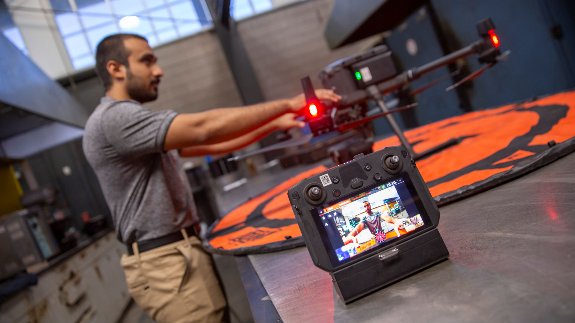
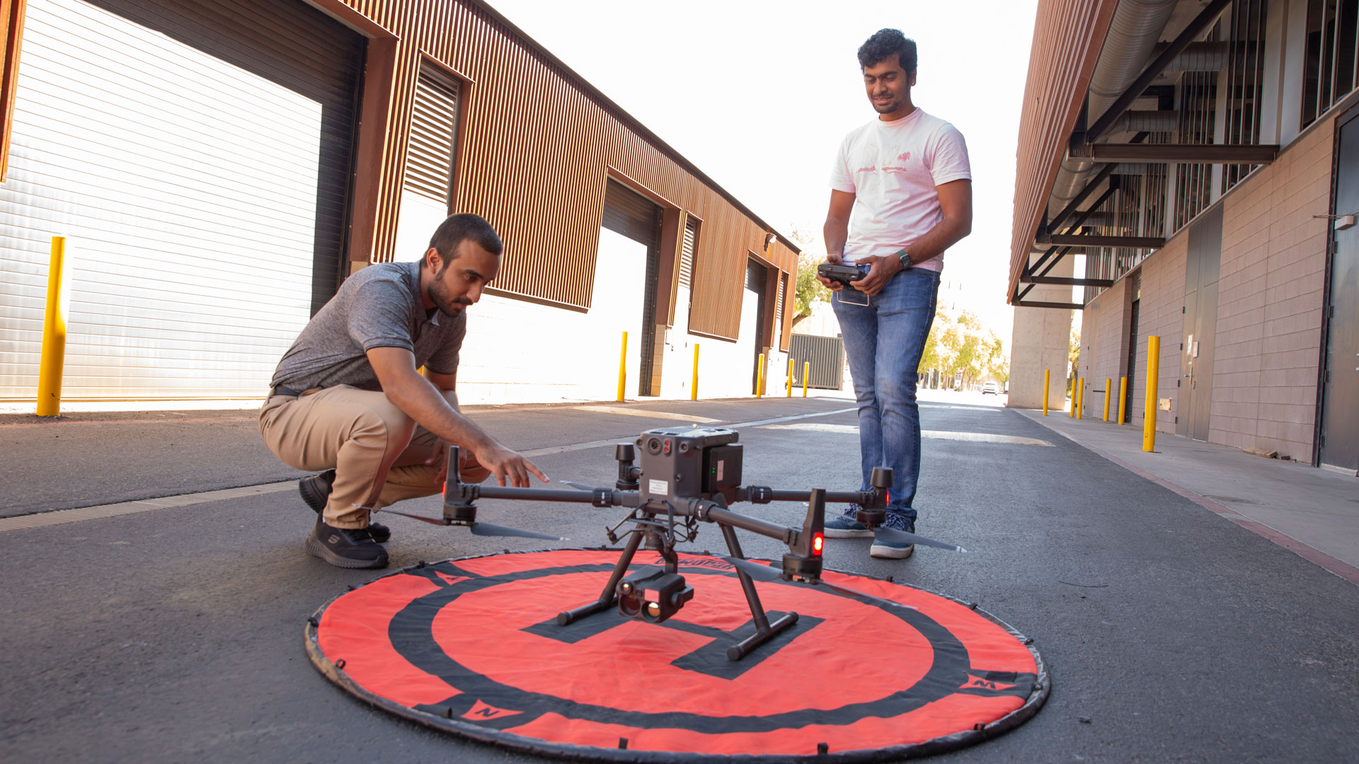
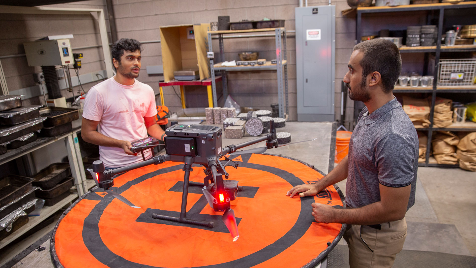
Drone imagery has produced accurate two-dimensional maps, elevation models, thermal maps, and three-dimensional maps. The use of unmanned aerial vehicles (UAV), also known as drones, has become ubiquitous in various civil engineering applications such as bridge inspection, building construction progress, monitoring, erosion control, etc. Artificial intelligence and deep learning brought further added value to the mapping processes to facilitate and accelerate computer vision tasks for image classification, object detection, and image segmentation. The use of drones in the pavement industry is limited to the detection of cracks and other distresses. In this project, the team proposes the use of drone technology equipped with a thermal camera to assess the effectiveness of various sustainable pavement treatments to mitigate heat island problems. Permeable pavements and reflective coatings are among pavement technologies to maintain a lower surface temperature. The drone technology can also be used to develop automated and near-real-time protocols that can be used for pavement construction quality inspection and control.
Mentor: Hasan Ozer

It’s hip to be square.
Students presenting projects at the Fulton Forge Student Research Expo are encouraged to download this personal QR code and include it within your poster. This allows expo attendees to explore more about your project and about you in the future.
Right click the image to save it to your computer.
Featured project | Summer 2023
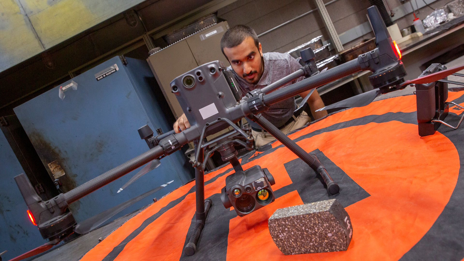
Civil engineering senior Othman Al-Alawi conducted research in the FURI program over the summer with mentor Hasan Ozer, an associate professor of civil, environmental and sustainable engineering. Al-Alawi’s research harnessed drones with thermal cameras to help evaluate sustainable pavement treatments’ impact on urban heat islands. His work has contributed to a research paper on which he is a co-author with Ozer’s doctoral students. The paper, “Thermal Profiling of Asphalt Pavement Construction using Uncrewed Aerial Vehicle (UAV),” was accepted to be presented at a major event hosted by the Transportation Research Board in Washington, D.C., and is under consideration for publication in the organization’s peer-reviewed research journal.
What made you want to get involved in FURI?
I decided to get involved in this program primarily because of my strong interest in gaining research experience, particularly within my field as a civil engineering student. The prospect of contributing to cutting-edge research and advancing my knowledge in this domain was highly appealing to me.
What was it like participating in FURI during the summer semester?
Participating in FURI over the summer was a unique experience. It was definitely a mix of fun and challenges. During the summer, I didn’t have any classes or academic commitments, which provided me with the perfect opportunity to fully immerse myself in research. Without the need to complete coursework, I could dedicate more time and energy to delve into FURI and apply the knowledge and skills I had gained from my classes directly to my research projects.
However, it was also quite demanding because I was simultaneously engaged in a full-time internship alongside my research commitments. Balancing both responsibilities required careful time management and dedication. There were times when it got a bit overwhelming, but the learning experience and the chance to apply classroom knowledge to practical situations made it all worthwhile. Overall, participating in FURI over the summer was a valuable and enriching experience.
Why did you choose the project you’re working on?
I made a conscious decision to align my project with my personal interests and career aspirations. I have always been fascinated by transportation infrastructure and the materials used in pavements for roads. This topic resonated with me on a deep level, and I saw it as an opportunity to delve into an area of civil engineering that I’m truly passionate about.
Furthermore, my commitment to the sustainable aspect of civil engineering played a significant role in my choice. I believe in the importance of environmentally responsible practices in infrastructure development, and this project allowed me to explore sustainable solutions within the realm of transportation and pavement materials.
How will your engineering research project impact the world?
My engineering research project is poised to make a substantial global impact through cost reduction, timely damage detection, enhanced infrastructure longevity, safety advancements, environmental responsibility and economic efficiency.
The research findings offer cities and municipalities an opportunity to significantly reduce their expenditure on recurrent road and parking pavement repairs. This financial relief is of paramount importance, especially in an era in which fiscal prudence is crucial for governments and local authorities.
Through the utilization of data derived from my research, we have established an effective system for promptly identifying damage in newly constructed pavements. This capability is instrumental in enabling immediate repairs before these issues worsen and compromise road safety and usability.
By minimizing the need for frequent and extensive repairs, my research promotes the durability of road and parking pavements. This, in turn, extends the life span of critical infrastructure, benefiting communities and economies alike.
The rapid identification and resolution of pavement damage contributes to safer road networks. This directly reduces the risk of accidents and injuries for all road users, making transportation systems safer and more reliable.
The sustainable practices advocated for in my research — reducing the frequency of construction and repair work — align with environmental conservation objectives. This aids in curbing the environmental impact typically associated with infrastructure projects, such as resource consumption and emissions.
The efficiency gains from optimized infrastructure maintenance made possible by this research enhance the economic health of cities. Effective allocation of resources not only benefits taxpayers but also fosters overall economic stability.
How do you see this experience helping with your career or advanced degree goals?
Participating in this experience has been instrumental in shaping and advancing my career and advanced degree goals in several ways.
This opportunity provided me with invaluable real-world insight into the field. It allowed me to see the practical application of the concepts and theories I’ve learned in my academic studies. This firsthand experience has deepened my understanding of how the field operates beyond the classroom.
As a researcher, I’ve acquired essential skills that are directly transferable to my career and advanced degree pursuits. These include skills in data collection, analysis and interpretation, as well as problem-solving and critical thinking. These skills are not only relevant to my current research but also to future projects and endeavors in my field.
This experience has also added depth and credibility to my resume. It demonstrates my commitment to practical, hands-on learning and research, which can be a distinguishing factor when applying for advanced degree programs or job opportunities in the future.
What is the best advice you’ve gotten from your faculty mentor?
My mentor emphasized the importance of embracing mistakes as valuable learning opportunities. Instead of fearing or avoiding them, I was encouraged to analyze my errors, understand the root causes and use this knowledge to improve and grow. This advice underscores the idea that setbacks and failures are not hindrances but rather steppingstones toward personal and professional development.
Another crucial piece of advice was “always ask if you don’t know,” which is the importance of seeking guidance and clarification when faced with uncertainty. I was encouraged to recognize that it’s perfectly acceptable to admit when I don’t have all the answers and to reach out for help or information.
Why should other students get involved in this program?
FURI provides an open and welcoming platform for students to explore their interests and passions. It allows them to pursue projects and topics that genuinely resonate with their academic and career aspirations. This level of freedom can be incredibly motivating and fulfilling.
It also offers students the opportunity to gain valuable hands-on experience in their chosen field. It’s an environment in which theoretical knowledge from the classroom can be applied in practical, real-world scenarios. This experience is instrumental in bridging the gap between academic learning and practical application.